Property Record
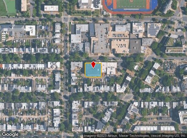
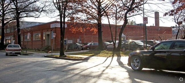
1250 Taylor St Nw, Washington, DC 20011


NEARBY LISTINGS FOR SALE OR LEASE
Property Detail
1250 Taylor St Nw
Washington-Arlington-Alexandria, DC-VA-MD-WV
Columbia Heights
2908-0067
SQUARE 2908 LOT 0067 NBHD: COLUMBIA HEIGHTS
Warehouse
District of Columbia
X
District of Columbia
24033C0110E
67
2025
0.52 AC
2025
Uptown
002503
Washington, DC
127,788 SF
DEMOGRAPHICS near 1250 Taylor St Nw
1 Mile
3 Mile
5 Mile
2024 Total Population
54,243
361,401
767,067
2029 Population
48,328
329,534
719,980
Pop Growth 2024-2029
(10.90%)
(8.82%)
(6.14%)
Average Age
37
38
38
2024 Total Households
22,090
172,581
349,253
HH Growth 2024-2029
(11.78%)
(9.68%)
(6.87%)
Median Household Inc
$104,741
$104,795
$106,300
Avg Household Size
2.30
2.00
2.10
2024 Avg HH Vehicles
1.00
1.00
1.00
Median Home Value
$755,677
$751,761
$750,626
Median Year Built
1947
1954
1960
Nearby Places
Map Layers
Map Styles
 Street
 Aerial
- Restaurants
- Banks
- Shops
- Fitness
- Groceries
PUBLIC TRANSPORTATION
TRANSIT/SUBWAY
Georgia Ave-Petworth (Green Line - Washington Metropolitan Area Transit Authority Metrorail (Metrorail), Yellow Line - Washington Metropolitan Area Transit Authority Metrorail (Metrorail))
DRIVE
WALK
Distance
Georgia Ave-Petworth (Green Line - Washington Metropolitan Area Transit Authority Metrorail (Metrorail), Yellow Line - Washington Metropolitan Area Transit Authority Metrorail (Metrorail))
1 min
9 min
0.5 mi
Columbia Heights (Green Line - Washington Metropolitan Area Transit Authority Metrorail (Metrorail), Yellow Line - Washington Metropolitan Area Transit Authority Metrorail (Metrorail))
DRIVE
WALK
Distance
Columbia Heights (Green Line - Washington Metropolitan Area Transit Authority Metrorail (Metrorail), Yellow Line - Washington Metropolitan Area Transit Authority Metrorail (Metrorail))
3 min
18 min
0.9 mi
COMMUTER RAIL
Lead (Fredericksburg Line - Virginia Railway Express, Manassas Line - Virginia Railway Express)
DRIVE
WALK
Distance
Lead (Fredericksburg Line - Virginia Railway Express, Manassas Line - Virginia Railway Express)
8 min
4.3 mi
Union Station (Brunswick Line - Maryland Area Regional Commuter Trains (The MARC), Camden Line - Maryland Area Regional Commuter Trains (The MARC), Fredericksburg Line - Maryland Area Regional Commuter Trains (The MARC), Manassas Line - Maryland Area Regional Commuter Trains (The MARC), Penn Line - Maryland Area Regional Commuter Trains (The MARC), Red Line - Maryland Area Regional Commuter Trains (The MARC))
DRIVE
WALK
Distance
Union Station (Brunswick Line - Maryland Area Regional Commuter Trains (The MARC), Camden Line - Maryland Area Regional Commuter Trains (The MARC), Fredericksburg Line - Maryland Area Regional Commuter Trains (The MARC), Manassas Line - Maryland Area Regional Commuter Trains (The MARC), Penn Line - Maryland Area Regional Commuter Trains (The MARC), Red Line - Maryland Area Regional Commuter Trains (The MARC))
10 min
4.4 mi
AIRPORT
Ronald Reagan Washington Ntl
DRIVE
WALK
Distance
Ronald Reagan Washington Ntl
17 min
7.8 mi
Washington Dulles International
DRIVE
WALK
Distance
Washington Dulles International
49 min
29.2 mi
Baltimore/Washington International Thurgood Marshall
DRIVE
WALK
Distance
Baltimore/Washington International Thurgood Marshall
46 min
34.2 mi
Freight Ports
Port of Baltimore
DRIVE
WALK
Distance
Port of Baltimore
50 min
37.1 mi
SALE & LEASE HISTORY
LISTING DATE
SALE/LEASE

Sep 24, 2016
For Lease
Dec 20, 2016
For Lease
Nearby Properties
Address
Land Use
TOTAL SIZE
Lot Size
Zoning
Address
Land Use
TOTAL SIZE
Lot Size
Zoning
2,300,000 SF
1.60 AC
D-5-R
Address
Land Use
TOTAL SIZE
Lot Size
Zoning
533,778 SF
18.08 AC
UNZONED
Address
Land Use
TOTAL SIZE
Lot Size
Zoning
1,583,364 SF
276.66 AC
UNZONED
Address
Land Use
TOTAL SIZE
Lot Size
Zoning
1,100,000 SF
2.13 AC
D-6
Address
Land Use
TOTAL SIZE
Lot Size
Zoning
1,310,661 SF
3.38 AC
D-6
Address
Land Use
TOTAL SIZE
Lot Size
Zoning
1,738,573 SF
2.11 AC
D-7
Address
Land Use
TOTAL SIZE
Lot Size
Zoning
1.57 AC
D-5
Address
Land Use
TOTAL SIZE
Lot Size
Zoning
2,247,684 SF
6.39 AC
D-4-R
Address
Land Use
TOTAL SIZE
Lot Size
Zoning
553,914 SF
55.91 AC
R-1B
Address
Land Use
TOTAL SIZE
Lot Size
Zoning
758,000 SF
2.22 AC
D-4-R;MU-7
Address
Land Use
TOTAL SIZE
Lot Size
Zoning
1,185,122 SF
2.43 AC
D-6
Address
Land Use
TOTAL SIZE
Lot Size
Zoning
1,562,988 SF
15.33 AC
MU-10 (IZ+
Address
Land Use
TOTAL SIZE
Lot Size
Zoning
479,505 SF
5 AC
D-6-R
Address
Land Use
TOTAL SIZE
Lot Size
Zoning
1,214,044 SF
1.48 AC
D-6
Address
Land Use
TOTAL SIZE
Lot Size
Zoning
469,183 SF
1.20 AC
D-5
Address
Land Use
TOTAL SIZE
Lot Size
Zoning
626,543 SF
5.29 AC
UNZONED
Address
Land Use
TOTAL SIZE
Lot Size
Zoning
4.87 AC
D-6
Address
Land Use
TOTAL SIZE
Lot Size
Zoning
512,068 SF
1.36 AC
D-5-R
Address
Land Use
TOTAL SIZE
Lot Size
Zoning
900,000 SF
12.60 AC
RA-4
Address
Land Use
TOTAL SIZE
Lot Size
Zoning
95.32 AC
RA-1
Address
Land Use
TOTAL SIZE
Lot Size
Zoning
314,995 SF
5.83 AC
D-5
Address
Land Use
TOTAL SIZE
Lot Size
Zoning
247,900 SF
170.58 AC
RA-2;UNZON
Address
Land Use
TOTAL SIZE
Lot Size
Zoning
1,018,056 SF
1.14 AC
D-6
Address
Land Use
TOTAL SIZE
Lot Size
Zoning
526,768 SF
1.03 AC
D-5-R
Address
Land Use
TOTAL SIZE
Lot Size
Zoning
776,520 SF
1.49 AC
MU-9B
Address
Land Use
TOTAL SIZE
Lot Size
Zoning
814,320 SF
0.99 AC
D-7
Address
Land Use
TOTAL SIZE
Lot Size
Zoning
379,921 SF
1.03 AC
D-5-R
Address
Land Use
TOTAL SIZE
Lot Size
Zoning
499,000 SF
1.49 AC
RA-4
Address
Land Use
TOTAL SIZE
Lot Size
Zoning
714,502 SF
1.54 AC
D-7
Address
Land Use
TOTAL SIZE
Lot Size
Zoning
431,570 SF
0.78 AC
D-6
The World's #1 Commercial Real Estate Marketplace
Connect with us
© 2025 CoStar Group
The information above has been obtained from sources believed reliable. While we do not doubt its accuracy we have not verified it and make no guarantee, warranty or representation about it. It is your responsibility to independently confirm its accuracy and completeness. Any projections, opinions, assumptions, or estimates used are for example only and do not represent the current or future performance of the property. The value of this transaction to you depends on tax and other factors which should be evaluated by your tax, financial, and legal advisors. You and your advisors should conduct a careful, independent investigation of the property to determine to your satisfaction the suitability of the property for your needs.